Home > Tag > Obliques

Welcome to the official site for FEMA's Great Lakes Coastal Flood Study, the comprehensive storm and wind study of the Great Lakes basin for the purpose of updating the coastal flood hazard information and Flood Insurance Rate Maps (FIRM) for Great Lakes coastal communities. Below you’ll find a list of the most recent meetings with their agendas, links to preliminary maps, and presentations. To the left you’ll find additional Great Lakes Coastal Flood Study content.

FEMA created this self-guided tutorial on coastal flood mapping that provides important information to coastal communities and their residents. FEMA’s “Coastal Hazards and Coastal Mapping: A Visual Guide” is a glossary of coastal mapping terms and a companion to the tutorial.

View all posts by lake: Lake Superior | Lake Michigan | Lake Huron | Lake St. Clair | Lake Erie | Lake Ontario

View all posts by state: Minnesota | Wisconsin | Illinois | Indiana | Michigan | Ohio | Pensylvania | New York


Posts

Oblique Photo Viewer Now Available

Great Lakes Coastal Flood Study reminds you to check out the Oblique Photo Viewer created by the US Army Corp of Engineers for this Federal Inter-Agency Initiative. This online resource of high resolution oblique imagery is used by the technical contractors for shoreline analysis in the Flood Study and is a valuable resource for the public and others interested in coastal issues on the Great Lakes.

Note: This site is currently being moved to a new host and is temporarily inaccessible. This note will be removed when it is back up and running again.
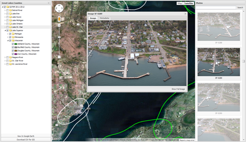
Links to resources like the Oblique Photo Viewer above are posted on the Technical Resources page.

Posted in Data.
Tags: , , .