
Baraga County, Michigan
CCO Meeting – CCO Meeting Presentation [.pdf]
Thursday, March 9, 2023, from 2-4pm ET
Open House:
Thursday, March 9, 2023, from 6-8pm ET
Welcome to the official site for FEMA's Great Lakes Coastal Flood Study, the comprehensive storm and wind study of the Great Lakes basin for the purpose of updating the coastal flood hazard information and Flood Insurance Rate Maps (FIRM) for Great Lakes coastal communities. Below you’ll find a list of the most recent meetings with their agendas, links to preliminary maps, and presentations. To the left you’ll find additional Great Lakes Coastal Flood Study content.
FEMA created this self-guided tutorial on coastal flood mapping that provides important information to coastal communities and their residents. FEMA’s “Coastal Hazards and Coastal Mapping: A Visual Guide” is a glossary of coastal mapping terms and a companion to the tutorial.
View all posts by lake: Lake Superior | Lake Michigan | Lake Huron | Lake St. Clair | Lake Erie | Lake Ontario
View all posts by state: Minnesota | Wisconsin | Illinois | Indiana | Michigan | Ohio | Pensylvania | New York
Baraga County, Michigan
CCO Meeting – CCO Meeting Presentation [.pdf]
Thursday, March 9, 2023, from 2-4pm ET
Open House:
Thursday, March 9, 2023, from 6-8pm ET
Flood Risk Review meetings held in Minnesota, Wisconsin and Michigan for Lake Superior:
Minnesota
Wisconsin
Michigan
The Federal Emergency Management Agency (FEMA) conducts scoping meetings to determine the riverine flood mapping update needs. These efforts are combined with the lake-wide coastal flood hazard mapping effort with the outcomes constituting the first basin-wide update of water-level statistics and flood hazard data compiled by the United States government for the Great Lakes in 25 years.
Under these riverine scoping efforts, a key phase in this study process is FEMA’s consultation with local communities through the conduct of a scoping meeting and the collection of data. FEMA uses these scoping meetings and follow-up conversation to collect information that will contribute to a better understanding of local flood risk conditions. A second purpose of this outreach is to provide a venue for sharing information related to study methodology and schedules.
County: Baraga, MI
Monday, August 11, 2014: 1pm – 3pm
Village of L’Anse
Council Chambers
101 N. Main Street
L’Anse, MI 49946
County: Alger, MI
Tuesday, August 12, 2014: 10am – Noon
Alger County Courthouse
101 Court Street
Munising, MI 49862
County: Mackinac, MI
Wednesday, August 13, 2014: 1pm – 3pm
St. Ignace Public Library
110 W. Spruce Street
St. Ignace, MI 49781
County: Emmet, MI
Wednesday, August 13, 2014: 1pm – 3pm
Bear Creek Township
373 North Division Road
Petoskey, MI 49770
County: Antrim, MI
Wednesday, August 13, 2014: 5pm – 7pm
Torch Lake Township
2355 N US-31
Kewadin, MI 49648
County: Benzie, MI
Thursday, August 14, 2014: 1pm – 3pm
Board of Commissioners Room
448 Court Place
Beulah, MI 49617
County: Delta, MI
Thursday, August 14, 2014: 3pm – 5pm
Bay College Escanaba
Student Center, Room 525
2001 N Lincoln Road
Escanaba, MI 49829
County: Manistee, MI
Thursday, August 14, 2014: 5pm – 7pm
Manistee County Sheriff’s Office
1525 E. Parkdale Avenue
Manistee, MI 49660
The Federal Emergency Management Agency (FEMA) conducts scoping meetings to determine the riverine flood mapping update needs. These efforts are combined with the lake-wide coastal flood hazard mapping effort with the outcomes constituting the first basin-wide update of water-level statistics and flood hazard data compiled by the United States government for the Great Lakes in 25 years.
Under these riverine scoping efforts, a key phase in this study process is FEMA’s consultation with local communities through the conduct of a scoping meeting and the collection of data. FEMA uses these scoping meetings and follow-up conversation to collect information that will contribute to a better understanding of local flood risk conditions. A second purpose of this outreach is to provide a venue for sharing information related to study methodology and schedules.
County: Kewaunee, WI
Monday, July 14, 2014: 1pm – 3pm
Kewaunee County Building
Health and Human Services Training Room
810 Lincoln Street
Kewaunee, WI 54216
County: Marinette, WI
Tuesday, July 15, 2014: 9:30am – 11:30am
Stephenson Public Library Community Room
1700 Hall Avenue
Marinette, WI 54143
County: Ashland, WI
Wednesday, July 16, 2014: 10am – 12 noon
Vaughn Public Library
2nd Floor Meeting Room
502 Main Street W
Ashland, WI 54806
County: St Louis, MN
Thursday, July 17, 2014: 9:30am – 11:30am
City Hall
Conference Room 303
411 W. 1st Street
Duluth, MN 55802
View the dates and locations of the upcoming Coastal Scoping Meetings for counties on Lake Superior and Lake Huron:
Lake Superior
View Map of Coastal Scoping Meetings for Lake Superior [.pdf]
Counties: Bayfield and Ashland, WI
Wednesday, April 30, 2014: 9am -12 noon
Vaughn Public Library
502 West Main Street
Ashland, WI 54806
Counties: St. Louis, MN and Douglas, WI
Thursday, May 1, 2014: 9am – 12 noon
County Building
1316 N 14th St
Conf Room 270
Superior, WI 54880
Counties: Cook and Lake, MN
Thursday, May 1, 2014: 1:30 pm – 4:30pm
Council Chambers at City Hall
522 First Avenue
Two Harbors, MN 55616
Counties: Baraga, Marquette and Alger, MI
Friday, May 9, 2014: 8:30am – 11:30am
Marquette County Courthouse
234 W Baraga Ave
Room 41
Marquette, MI 49855
Lake Huron
View Map of Coastal Scoping Meetings for Lake Huron [.pdf]
Counties: Sanilac and St. Clair, MI
Monday, May 5, 2014: 8:30am – 11:30am
Lexington Community Center
6964 Huron Avenue
Lexington, MI 48450
Counties: Bay and Huron, MI
Monday, May 5, 2014: 2pm – 5pm
City Hall Room 317
301 Washington Avenue
Bay City, MI 48708
Counties: Iosco and Arenac, MI
Tuesday May 6, 2014: 8:30am – 11:30am
East Tawas City Hall
760 Newman Street
East Tawas, MI 48730
Counties: Alpena and Alcona, MI
Tuesday, May 6, 2014: 2pm – 5pm
Alpena Township Conference Room
4385 US 23 North
Alpena, MI 49707
Counties: Cheboygan and Presque Isle, MI
Wednesday, May 7, 2014: 8:30am – 11:30am
Cheboygan City Hall
403 N. Huron Street
Cheboygan, MI 49721
Counties: Chippewa and Mackinac, MI
Thursday, May 8, 2014: 9:00am – Noon
Bayliss Public Library Community Room
511 Library Drive
Sault Ste Marie, MI 49783
Now available on the Digital Coast – 900 linear kilometers of bathymetric lidar for Lake Superior!
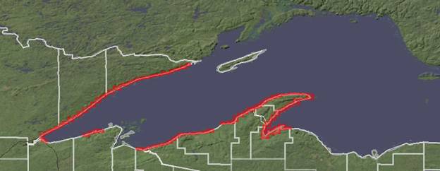
Using funding from the EPA Great Lakes Restoration Initiative, NOAA Coastal Services Center worked with regional stakeholders, including state agencies, federal agencies, regional working groups, international management bodies, and tribes, to determine the priority areas for collection. The data set was contracted for collection by FUGRO LADS, and excellent communication between CSC and the contractor maximized the quality of the end product. This data set will be critical to the success of many restoration projects, modeling of lake level change, and any analysis that requires a seamless elevation surface above and below the water.
To access the data set, visit http://csc-s-maps-q.csc.noaa.gov/dataviewer/viewer.html?keyword=lidar or, for more information, contact Lindy Betzhold.