Now available on the Digital Coast – 900 linear kilometers of bathymetric lidar for Lake Superior!
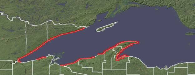
Using funding from the EPA Great Lakes Restoration Initiative, NOAA Coastal Services Center worked with regional stakeholders, including state agencies, federal agencies, regional working groups, international management bodies, and tribes, to determine the priority areas for collection. The data set was contracted for collection by FUGRO LADS, and excellent communication between CSC and the contractor maximized the quality of the end product. This data set will be critical to the success of many restoration projects, modeling of lake level change, and any analysis that requires a seamless elevation surface above and below the water.
To access the data set, visit http://csc-s-maps-q.csc.noaa.gov/dataviewer/viewer.html?keyword=lidar or, for more information, contact Lindy Betzhold.