News from NOAA Coastal Services Center:
Topographic and Bathymetric Data Inventory:
http://www.csc.noaa.gov/topobathy/
The first comprehensive inventory of elevation data sets for the nation is now available. NOAA and FEMA have worked together to inventory elevation data, both topographic and bathymetric, for all 50 states and Puerto Rico.
The NOAA inventory initially focused on coastal elevation data, and a partnership with FEMA allowed expansion to the interior of the country. The inventory’s data viewer provides
- searching of the NOAA and FEMA inventories,
- enhanced functionality to create data reports,
- new zooming capabilities,
- printable custom maps of elevation resources,
- an innovative design for displaying information about data sets, including quality, and
- direct links to the data source whenever available.
The inventories can be used not only to locate the data needed when developing elevation models, but also to discover where data gaps exist. The data sets and data quality information found in these inventories are critical components of efforts to address issues related to flooding, beach nourishment, and erosion.
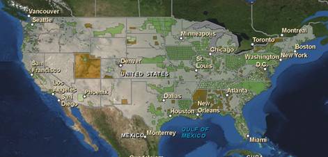
The NOAA inventory includes both topographic and bathymetric data and covers many coastal areas of the nation. This inventory represents data sets found during an exhaustive search for elevation data and portrays a snapshot in time of the elevation resources for a region. The FEMA inventory includes topographic data and covers the entire nation, including Puerto Rico. This effort was conducted January through June 2010 to support FEMA’s internal planning. It focused primarily on large data sets available for an area rather than an all-inclusive collection.
The next steps for this project are to incorporate information verification done by U.S. Geological Survey liaisons and combine the inventories for a single look at elevation resources for the nation.
Explore the site at www.csc.noaa.gov/topobathy/ to find out what elevation data are available for your area, or contact Lindy Betzhold for more information.