Home > 2011

Welcome to the official site for FEMA's Great Lakes Coastal Flood Study, the comprehensive storm and wind study of the Great Lakes basin for the purpose of updating the coastal flood hazard information and Flood Insurance Rate Maps (FIRM) for Great Lakes coastal communities. Below you’ll find a list of the most recent meetings with their agendas, links to preliminary maps, and presentations. To the left you’ll find additional Great Lakes Coastal Flood Study content.

FEMA created this self-guided tutorial on coastal flood mapping that provides important information to coastal communities and their residents. FEMA’s “Coastal Hazards and Coastal Mapping: A Visual Guide” is a glossary of coastal mapping terms and a companion to the tutorial.

View all posts by lake: Lake Superior | Lake Michigan | Lake Huron | Lake St. Clair | Lake Erie | Lake Ontario

View all posts by state: Minnesota | Wisconsin | Illinois | Indiana | Michigan | Ohio | Pensylvania | New York


Posts

International Upper Great Lakes Study Progress Report

In 2007, the International Joint Commission launched a five-year study to look at future water levels in the upper Great Lakes and the options for regulating those levels to support the region’s economic and environmental interests. In the entire upper lakes basin, water levels are currently influenced through a regulation plan at the St. Marys River control structures at Sault Ste. Marie, where Lake Superior outflows have been regulated since 1914.

Please view the Progress Report from the International Upper Great Lakes Study at this link

More information about the International Upper Great Lakes Study on their website: http://www.iugls.org/

Posted in Important Updates.
Tags: .


Presentation from Ohio Statewide Floodplain Management Conference

The following presentation related to the Great Lakes Coastal Flood Study was presented at the Ohio Statewide Floodplain Management Conference in July. Use the link below to view the presentation:

The Presentation above is posted on the Presentations page.

Posted in Presentations.
Tags: , .


Outreach Page Expanded at greatlakescoast.org

We’ve expanded the Outreach Page of GreatLakesCoast.org!

The Outreach Page now contains the following sub-sections:

Please check out the new sections using the links above or go to the Outreach Page to see an overview of what each section is about. Thanks!

NVision Solutions Contracted by U.S. Army Corps of Engineers to Help with Flood Plain Management

via http://www.directionsmag.com/pressreleases/nvision-solutions-contracted-by-corps-of-engineers-for-great-lakes-flood-pl/182546

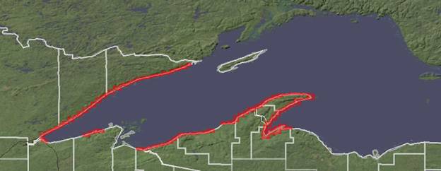
NVision Solutions, Inc. has been awarded a contract by the U.S. Army Engineer Research and Development Center (ERDC) in Vicksburg, MS, to provide aerial-data collection services for the entire Great Lakes Region coastline to help with flood plain management. NVision will provide seamless, high-resolution oblique color images along approximately 6,000 miles of the coastline of all five Great Lakes within the U.S. The flights will test the new ERDC system and support other U.S. Army Corps of Engineer (USACE) activities. NVision has partnered with Aerotec, LLC to use their specialized Partenavia P68C fixed-wing aircraft and FAA-certified flight operations team. “We are pleased to partner with Aerotec as we have routinely partnered with them on several geospatial engineering projects,” said NVision President Socorro Harvey. “Together, we are like a well-oiled machine.” Aerotec is based in Bessemer, Alabama with offices in Picayune, MS. The data collection, which will require weeks of flight-time with nightly transfer of data for quality control, will be used with various Google technologies for documentation and can be used for rapid response for any type of event. Both NVision and Aerotec are active members of the EIGS geospatial technology cluster of the Magnolia Business Alliance (MBA). MBA’s goal is to impact economic development by serving as an advocate for small and medium-sized businesses. NVision, headquartered near the NASA Stennis Space Center in south Mississippi, is an established defense contractor for geospatial technology and services including several subcontracts to U.S. Army Corps of Engineers (USACE) prime contractors. NVision also served the USACE through multiple FEMA contracts related to Hurricane Katrina. NVision is available through the U.S. General Services Administration (GSA) Schedule 70 contract; however, USACE issued this contract as an 8(a) competitive award. NVision’s status as an 8(a) minority, woman-owned company allows the USACE to meet multiple specific federal contracting requirements.

NVision Solutions, Inc. is a small, disadvantaged, minority, woman-owned certified 8(a) firm specializing in advanced geospatial solutions. NVision, headquartered near the NASA Stennis Space Center in south Mississippi, is an active member of the EIGS geospatial technology cluster of the Magnolia Business Alliance (MBA). MBA’s goal is to impact economic development by serving as an advocate for small and medium sized businesses. For more information about NVision Solutions, Inc., visit http://www.NVisionSolutions.com.

Aerotec, LLC is a value-added services company. Aerotec uses state-of-the-art airborne remote sensing (data capture) and data analysis technologies to provide topographic maps and models to its customers throughout North America. Aerotec’s primary technologies include Light Detection and Ranging (LIDAR/laser-scan), digital photography, proprietary and commercial (off-the-shelf) software, and specialized engineering analysis packages. Aerotec is an active member of the EIGS geospatial technology cluster of the Magnolia Business Alliance (MBA). MBA’s goal is to impact economic development by serving as an advocate for small and medium sized businesses. For more information about Aerotec, visit http://www.aerotecusa.com/.

Posted in Press Releases.
Tags: , , .


Presentations from ASFPM 2011 Annual Conference

The following presentations related to the Great Lakes Coastal Flood Study were presented at the Association of State Floodplain Managers (ASFPM) 2011 Annual Conference in Louisville. Use the links below to view the presentations:

The Presentations above are posted on the Presentations page.

Posted in Presentations.
Tags: , , , .


New Bathymetric Lidar for the Lake Superior Shoreline

Now available on the Digital Coast – 900 linear kilometers of bathymetric lidar for Lake Superior!

NOAA Lake Superior Lidar

Using funding from the EPA Great Lakes Restoration Initiative, NOAA Coastal Services Center worked with regional stakeholders, including state agencies, federal agencies, regional working groups, international management bodies, and tribes, to determine the priority areas for collection. The data set was contracted for collection by FUGRO LADS, and excellent communication between CSC and the contractor maximized the quality of the end product. This data set will be critical to the success of many restoration projects, modeling of lake level change, and any analysis that requires a seamless elevation surface above and below the water.

To access the data set, visit http://csc-s-maps-q.csc.noaa.gov/dataviewer/viewer.html?keyword=lidar or, for more information, contact Lindy Betzhold.

Presentations from 2011 NYSFSMA Conference

The following two presentations related to the Great Lakes Coastal Flood Study were presented at the New York State Floodplain and Stormwater Managers Association (NYSFSMA) Conference on April 28th, 2011. Use the links below to view the presentations from US Army Corps of Engineers and Baird:

The Presentations above are posted on the Presentations page.

Comprehensive Elevation Inventory for the United States Now Available

News from NOAA Coastal Services Center:

Topographic and Bathymetric Data Inventory:
http://www.csc.noaa.gov/topobathy/

The first comprehensive inventory of elevation data sets for the nation is now available. NOAA and FEMA have worked together to inventory elevation data, both topographic and bathymetric, for all 50 states and Puerto Rico.

The NOAA inventory initially focused on coastal elevation data, and a partnership with FEMA allowed expansion to the interior of the country. The inventory’s data viewer provides

  • searching of the NOAA and FEMA inventories,
  • enhanced functionality to create data reports,
  • new zooming capabilities,
  • printable custom maps of elevation resources,
  • an innovative design for displaying information about data sets, including quality, and
  • direct links to the data source whenever available.

The inventories can be used not only to locate the data needed when developing elevation models, but also to discover where data gaps exist. The data sets and data quality information found in these inventories are critical components of efforts to address issues related to flooding, beach nourishment, and erosion.

NOAA Topobathy

The NOAA inventory includes both topographic and bathymetric data and covers many coastal areas of the nation. This inventory represents data sets found during an exhaustive search for elevation data and portrays a snapshot in time of the elevation resources for a region. The FEMA inventory includes topographic data and covers the entire nation, including Puerto Rico. This effort was conducted January through June 2010 to support FEMA’s internal planning. It focused primarily on large data sets available for an area rather than an all-inclusive collection.

The next steps for this project are to incorporate information verification done by U.S. Geological Survey liaisons and combine the inventories for a single look at elevation resources for the nation.

Explore the site at www.csc.noaa.gov/topobathy/ to find out what elevation data are available for your area, or contact Lindy Betzhold for more information.

New Fact Sheets Released

Great Lakes Coastal Flood Study announces the release of two new fact sheets. The first fact sheet summarizes the Great Lakes Coastal Flood Study. The second fact sheet discusses water levels on the Great Lakes:

The Fact Sheets above are posted on the Fact Sheet page.

Great Lakes Coastal Flood Study (GLCFS)

If you are new to the site, start at Great Lakes Coastal Analysis & Mapping or use the links on the left to jump into the information on the Great Lakes Coastal Flood Study (GLCFS).

Posted in Website Administration.
Tags: .